
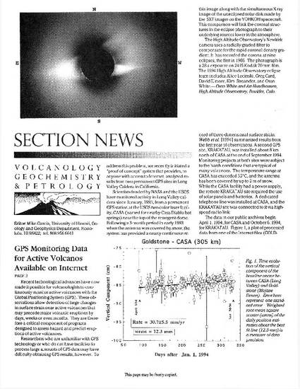
Recent technological advances have now made it possible for volcanologists to continuously monitor active volcanoes with the Global Positioning System (GPS). These observations allow detection of large changes in surface strain near active volcanoes that may precede major volcanic eruptions by days, weeks or even months. They are therefore a critical component of programs designed to assess hazard and predict eruptions of active volcanoes.
Researchers who are unfamiliar with GPS technology or who do not have facilities to process large amounts of GPS data may have difficulty obtaining GPS results, however. To address this problem, we recently initiated a “proof of concept” system that provides, to anyone with access to Internet, analyzed results from two permanent GPS sites in Long Valley Caldera in California.
Eos, Transactions American Geophysical Union, v. 76, issue 1, p. 2-3
©1995. American Geophysical Union. All Rights Reserved.
Available at: http://works.bepress.com/timothydixon/119/