
Article
Integrating Lidar‐Derived Tree Height and Landsat Satellite Reflectance to Estimate Forest Regrowth in a Tropical Agricultural Landscape
Remote Sensing in Ecology and Conservation
(2016)
Abstract
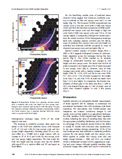
Remotely sensed data have revealed ongoing reforestation across many tropical landscapes. However, most studies have quantified changes between discrete land cover categories that are difficult to relate to the continuous changes in forest structure that underlie reforestation. Here, we demonstrate how generalized linear models (GLMs) can predict tree height and tree canopy cover from Landsat satellite reflectance in a 109 882 ha tropical agricultural landscape of western Panama. We derived tree canopy cover and tree height from airborne Light Detection and Ranging (LiDAR) data, and related these variables to the fraction of photosynthetic vegetation (PV) in Landsat pixels. We found large gains in predictive accuracy from modeling tree canopy height with a gamma GLM and tree canopy cover with a binomial GLM, relative to modeling these variables using linear regression. Adding social and environmental covariates to our GLMs, including topography and parcel membership (representing different land owners), increased predictive accuracy, resulting in best-fit models with an R<sub>2</sub> of 55.68% and RMSE of 23.69% for tree canopy cover, and an R<sub>2</sub> of 51.24% and RMSE of 3.42 m for tree height. Finally, we applied the GLMs to predict tree height and tree canopy cover in Landsat images from c. 2000 to 2012, and used results to quantify changes in forest structure during this 12-year period. We found that >60% of pixels in our study area had increased in tree height and tree canopy cover, suggesting widespread forest regrowth. These increases were spatially widespread across the study area, yet subtle, with most pixels increasing <2 m in tree height. Our results suggest ecological and agricultural changes that could be overlooked if measuring land cover change with discrete forest and non-forest categories. Overall, we show the advantages of linking LiDAR and Landsat data to quantify forest regrowth in an agricultural landscape.
Keywords
- continuous change detection,
- forest landscape restoration,
- Landsat-LiDAR integration,
- reforestation,
- spectral mixture analysis,
- tropical secondary forest
Publication Date
December 16, 2016
DOI
10.1002/rse2.33
Citation Information
T. Trevor Caughlin, Sami W. Rifai, Sarah J. Graves, Gregory P. Asner, et al.. "Integrating Lidar‐Derived Tree Height and Landsat Satellite Reflectance to Estimate Forest Regrowth in a Tropical Agricultural Landscape" Remote Sensing in Ecology and Conservation Vol. 2 Iss. 4 (2016) p. 190 - 203 Available at: http://works.bepress.com/timothy-caughlin/3/
Creative Commons license

This work is licensed under a Creative Commons CC_BY-NC-ND International License.