
Article
Reinterpreted history of latest Pleistocene Lake Bonneville: Geologic setting of threshold failure, Bonneville flood, deltas of the Bear River, and outlets for two Provo shorelines, southeastern Idaho, USA
Geological Society of America Field Guide
(2011)
Abstract
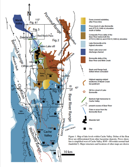
Geologic, geomorphic, and geophysical analyses of landforms, sediments, and geologic structures document the complex history of pluvial Lake Bonneville in northern Cache Valley, NE Great Basin, and shows that the outlet of Lake Bonneville shifted ~20 km south after the Bonneville flood. The Riverdale normal fault offsets Bonneville deposits, but not younger Provo deposits ~25 km southeast of Zenda, Idaho. Rapid changes in water level may have induced slip on the Riverdale fault shortly before, during, or after the Bonneville flood. Although other processes may have played a role, seismicity might have been the main cause of the Bonneville flood. The outlet of Lake Bonneville shifted south from Zenda first 11, then another 12 km, during the Provo occupation. The subsequent Holocene establishment of the drainage divide at Red Rock Pass, south of Zenda, resulted from an alluvial fan damming the north-sloping valley. Weak Neogene sediments formed sills for the three overflowing stages of the lake, including the pre-flood highstand. Field trip stops on flood-modified landslide deposits overlook two outflow channels, examine and discuss the conglomerate-bearing sedimentary deposits that formed the dam of Lake Bonne ville, sapping-related landforms, and the Holocene alluvial fan that produced the modern drainage divide at Red Rock Pass. The flood scoured ~25 km of Cache and Marsh Valleys, initiated modest-sized landslides, and cut a channel north of a new sill near Swan Lake. Lake Bonneville dropped ~100 m and stablilized south of this sill at the main, higher ~4775 ± 10 ft (1456 ± 3 m) Provo shoreline. Later Lake Bonneville briefly stabilized at a lower ~4745 ± 10 ft (1447 ± 3 m) Provo sill, near Clifton, Idaho, 12 km farther south. An abandoned meandering riverbed in Round Valley, Idaho, shows major flow of the large Bonneville River northward from the Clifton sill. Field trip stops at both sills and overlooking the meander belt examine some of the field evidence for these shorelines and sills. The Bear River, which enters Cache Valley at the mouth of Oneida Narrows, 17 km ENE of the Clifton sill, was the main source of water in Lake Bonneville. It produced 3 sets of deltas in Cache Valley—a major delta during the Bonneville highstand, a larger composite delta during occupation of two Provo shorelines, and at least one smaller delta during recession from the Provo shoreline. The Bonneville delta and most of the Provo delta of the Bear River were subaqueous in Cache Valley, based on their topsets being lower than the coeval shorelines. The Bonneville delta is deeply dissected by closely spaced gullies that formed immediately after the Bonneville flood. The delta morphologies change sequentially from river-dominated to wave- dominated, then back to river-dominated. These unique shapes and the brief, intense erosion of the Bonneville delta record temporal changes in wave energy, erosion, vegetation, and/or storminess, at the end of the Pleistocene. Stops on a delta near Weston, Idaho, reveal many of the distinguishing features of the much larger deltas of the Bear River in a smaller, more concentrated form. We will see and discuss the ubiquitous gully erosion in Bonneville landforms, the nearly undissected Provo delta, the subaqueous topset of the Provo delta, and the wave-cut and wave-built benches and notches at the upper and lower Provo shorelines.
Keywords
- Pleistocene Lake Bonneville,
- Geologic Setting,
- Provo shoreline
Disciplines
Publication Date
January 1, 2011
Citation Information
Janecke, S.U., and Oaks, R.Q., Jr., 2011, Reinterpreted history of latest Pleistocene
Lake Bonneville: Geologic setting of threshold failure, Bonneville flood, deltas of
the Bear River, and outlets for two Provo shorelines, southeastern Idaho, USA,
in Evans, J.P., and Lee, J., eds., Geologic Field Trips to the Basin and Range,
Rocky Mountains, Snake River Plain, and Terranes of the U.S. Cordillera:
Geological Society of America Field Guide 21, p. 193–220,
doi:10.1130/2011.0021(09). SEE ALSO Janecke and Oaks, 2011 a