
Article
Cache Valley: A Critical Part of Lake Bonneville, Record Possible Triggers of the Bonneville Flood, Protracted Bonneville Highstand, Liquefaction, and Cl
Lake Bonneville symposium, UGS
(2019)
Abstract
ABSTRACT
Geologic, geomorphic, and geophysical analyses of landforms, sediments, and structures in conjunction with new radiocarbon (14C) and optically stimulated luminescence (OSL) age determinations document a revised history of flooding and recession of Lake Bonneville in Cache Valley, Idaho and Utah. The presence of wave-cut cliffs in bedrock throughout the Bonneville basin show that the Bonneville highstand was protracted. Triangular facets were cut into bedrock in the footwalls of normal faults, and were steepened significantly by wave erosion at the highest Bonneville shoreline.
Crosscutting relationships associated with the Riverdale fault in SE Idaho, suggest that a major surface-rupturing earthquake occurred near the Zenda threshold at the north end of Cache Valley around the time of the Bonneville flood (Janecke and Oaks, 2011a and b). Thus, it is likely that fluctuating loads, rebound, and/or pore pressures induced by changing lake levels may have triggered a large earthquake that in turn initiated the Bonneville flood. The flood ended centuries of stable outflow through the Zenda threshold.
G.K. Gilbert (1880, 1890) first observed that the Bonneville flood scoured a major flood channel from Cache Valley northward that shifted the outlet of Lake Bonneville a great distance southward into Cache Valley. The bedrock sill at the south end of this Swan Lake scour channel became the new threshold for the main 1455 ± 3 m Provo shoreline, 10 m above the commonly accepted altitude of 1445 m (Janecke and Oaks, 2011a and b). The 1445 m contour in northern Cache Valley coincides instead with a lower Provo shoreline (1446 ± 3 m) that was controlled by a second bedrock sill southeast of Clifton, Idaho. The sparse record of shorelines rebounded from the ~1445 m level in Cache Valley indicate that the outlet at Clifton, Idaho was quickly abandoned when Lake Bonneville reverted to closed-basin conditions. A dry meandering riverbed connects the Clifton and Swan Lake outlets and preserves evidence of the large northward-flowing Bonneville River across Round Valley. The Great Basin's modern divide at Red Rock Pass formed in the Holocene, after Lake Bonneville, when an eastern tributary near the midpoint of the relict flood channel of the Bonneville River built a small alluvial fan across the Swan Lake scour channel and created a subtle drainage divide (Gilbert 1880, 1890; Janecke and Oaks, 2011a and b). Gilbert was the first to recognize that that the modern drainage divide at Red Rock Pass is unrelated to Lake Bonneville.
The possibility that an earthquake triggered the Bonneville flood (Janecke and Oaks, 2011a and b) led us to explore the late Pleistocene activity of normal faults in and near Cache Valley. Just west of Cache Valley, the Wasatch fault zone has increased its slip rate since the Bonneville flood (Hetzel and Hampel, 2005; Karow and Hampel, 2010 and citations therein), but little is known about the response of active normal faults in Cache Valley to loading and unloading by Lake Bonneville. To examine the relationships between ancient seismicity and lake history, we re-excavated deformed Upper Pleistocene sandy lake beds along a ~50 m by 5 m collapsed north wall of an abandoned gravel pit at the mouth of Green Canyon in Cache Valley, Utah. Utah State University faculty identified two liquefaction events in the outcrop in the 1980s during class trips, and we sought to determine the number, nature, and age of the paleo-earthquakes responsible for the strong deformation there.
Keywords
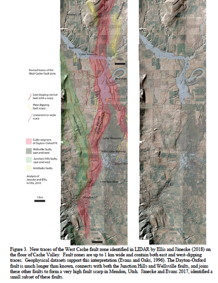
- West Cache fault zone,
- LIDAR,
- East Cache fault,
- earthquakes,
- flexure,
- loading
Disciplines
Publication Date
2019
Citation Information
Jänecke, S.U., Oaks, R.Q., Jr., Rittenour. T.M., Knight, A.J., Oakeson, J., and Ellis, N., 2019, Cache Valley: A Critical Part of Lake Bonneville, Record Possible Triggers of the Bonneville Flood, Protracted Bonneville High stand, Liquefaction, and Clustered Earthquakes on East and West Cache Fault Zones. In W.R. Lund, A.P. McKean, and S.D. Bowman (Eds.), Proceedings Volume: 2018 Lake Bonneville Geologic Conference and Short Course. Day 2, Sessions 5-8; Utah Geological Survey. Miscellaneous Publication, MP-170-2, p. 68-134. 8 p. article and 58 p. of presentation. https://ugspub.nr.utah.gov/publications/misc_pubs/mp-170/mp-170-2.pdf