
Other
Geologic map of the Lima Peaks 7.5' quadrangle, Beaverhead County, Montana
(2017)
Abstract
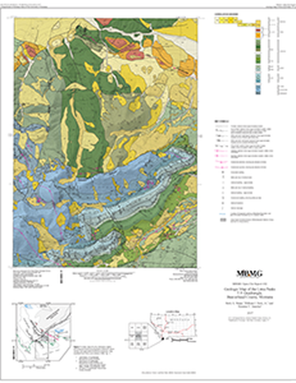
INTRODUCTION The Lima Peaks quadrangle is located in southwestern Beaverhead County in southwestern-most Montana, near the southern terminus of the Beaverhead Mountains (fig. 1). Rocks and deposits of Mississippian through Quaternary age are present along the eastern margin of the Cretaceous to early Tertiary Sevier fold-and-thrust belt. This area is structurally complex because rocks of the thrust belt structurally interacted with the southwestern terminus of the northeast-trending, older, Laramide Blacktail–Snowcrest uplift (Perry and others, 1988; Skipp, 1988; Lonn and others, 2006). Scholten and others (1955) published the first detailed geologic map of a large area that included this quadrangle. The authors provided detailed descriptions of the stratigraphy and presented structural interpretations that predated the development of modern plate tectonics and thrust belt theory. Their interpretations included foreland-dipping decollements and gravity sliding. Ryder and Scholten (1973, updated 1985) published a locally more detailed map of the area that emphasized the conglomerates of the Beaverhead Group. The first structural interpretations of the area that included hinterland-dipping thrust faults and decollements were presented in the 1980s by several authors including Hammons (1981); Perry and others (1981); Perry and others (1983); Perry and others (1988); and Skipp (1988). These authors also recognized the “thin-skinned” nature of the Tendoy thrust fault. Dougherty (1997) detailed deposition of the Beaverhead Group conglomerates in a foreland basin environment. Several large blocks of Mississippian limestone (indicated by a pattern on the map), described by Ryder and Scholten (1973/1985), and Perry and others (1988) as “slide blocks,” are now interpreted as large limestone blocks carried along at or near the bases of footwall thrusts as they formed. Thus, they were preserved at or near the leading edges of eroded thrust imbricates in the footwall of the Lima thrust (Susanne Janecke in Lonn and others, 2006). The current, more detailed map shows a limestone block in Birch Creek, now within a landslide, near the leading buried edge of a footwall imbrication. Synclinal folding and subsequent normal faulting modified and redistributed other blocks within the footwall. Still others are sedimentary and not related to any recognized structure. The three authors completed most field mapping for the Lima Peaks map in the 1980s, 1990s, and 2000s. Juanita MacKenzie assisted Skipp in the field in 1980–1982, June Skinner assisted in 1992, and Jean LaDue in 1981, 1982, 1997–1998, and 2000-2002. Mike Wells and Steve Richards assisted Perry during the 1980s, and he worked in consultation with R.T. Ryder and J.C. Haley during that same time. Susanne Janecke worked in the area sporadically from 1997 through 2004. Descriptions of Cretaceous rocks are based on measured sections of Blackleaf Formation and the lower part of the Frontier Formation (Dyman, 1985) located in the southeastern corner of the Lima Peaks quadrangle. Descriptions of the Cretaceous rocks also include seminal published works by Dyman, Perry, Tysdal, and others in 1997 and 2008. Older geologic maps of the area immediately surrounding this quadrangle include those of Scholten and others (1955), Ryder and Scholten (1973), and an open-file geologic map of the Edie Ranch 15' quadrangle (Skipp and others, 1979). The Lima Peaks quadrangle is one of 36 7.5' quadrangles within a preliminary geologic map compilation of the Lima 30' x 60' quadrangle (Lonn and others, 2006). Significant parts of that map were compiled from maps by co-authors Skipp, Ruppel, and Janecke. Skipp compiled the geology of the Lima Peaks quadrangle in 2016. Janecke acknowledges support from the National Science Foundation, American Chemical Society, and the EDMAP and Minerals programs of the U.S. Geological Survey. The map benefited greatly from reviews by Mitchell W. Reynolds and Erin Marsh, U.S. Geological Survey; and Colleen Elliott and Petr Yakovlev, Montana Bureau of Mines and Geology
Keywords
- fold and thrust belt,
- Sevier thrusts,
- lateral ramp,
- Tendoy normal fault,
- megabreccia blocks in Beaverhead conglomerate,
- no evidence for paleoriver of Sears
Disciplines
Publication Date
2017
Citation Information
Skipp, B.A., Perry, W.J. Jr., and Janecke, S.U., 2017, Geologic map of the Lima Peaks 7.5' quadrangle, Beaverhead County, Montana: Montana Bureau of Mines and Geology Open-File Report 692, 1 sheet, scale 1:24,000.