
Presentation
The Value of Travelers’ Itineraries in Archaeological Research: A GIS Analysis of Pathways through the Mani Peninsula, Greece
Annual Meeting of the American Schools of Oriental Research
(2017)
Abstract
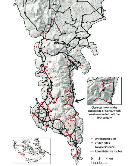
Winner of the 2017 ASOR Joy Ungerleider Poster Award. This poster presents the results of a Geographic Information Systems (GIS) analysis of major itineraries followed by visitors to the Mani Peninsula, Greece, over the past two millennia. The earliest "travel writer" to visit was Pausanias in the 2nd century AD. Beginning in the 15th century, many more cartographers, geographers, and tax officials began exploring the peninsula, leaving us their accounts and observations about the contemporary and ancient sites they encountered. Our analysis demonstrates that geographical considerations and political motivations often influenced the paths taken by travelers. As a result, their coverage of mountainous landscapes was limited, and many important sites were omitted from their written accounts. It is critical for modern scholars to continue investigating the "empty" areas on the map where early adventures did not stray.
Keywords
- Landscape archaeology,
- Greece,
- Early Modern,
- Travellers,
- GIS
Disciplines
Publication Date
November 15, 2017
Location
Boston, MA
Citation Information
Seifried, Rebecca M. and Chelsea A.M. Gardner (2017) “The Value of Travelers’ Itineraries in Archaeological Research: A GIS Analysis of Pathways through the Mani Peninsula, Greece." Poster presented at the Annual Meeting of the American Schools of Oriental Research, November 15–18, Boston, MA.
Creative Commons License

This work is licensed under a Creative Commons CC_BY-NC-SA International License.