
Presentation
Mapping Ottoman-Period Settlement Patterns with Remotely Sensed Imagery, GPS, and GIS
1st Annual Meeting of the Computer Applications and Quantitative Methods in Archaeology – Greece Chapter
(2014)
Abstract
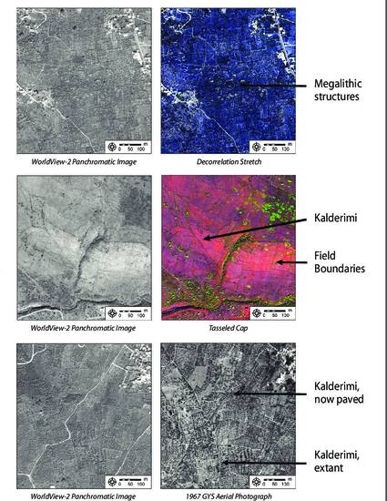
Building upon previous internship work at the Institute of Mediterranean Studies – Foundation for Research and Technology Hellas (IMS-FORTH), this poster presents a methodology for identifying, mapping, and spatially analyzing changing settlement patterns. Road atlases, historic archival records, and remotely sensed imagery are synthesized to create a preliminary GIS, then archaeological fieldwork targets individual features within a settlement to gather GPS points and establish dates. A second round of digitization results in a highly detailed GIS that records the changing landscape of human settlement in the region. The final step, spatial analysis, tests for significant relationships at both the intra- and inter-settlement scales.
Keywords
- Settlement patterns,
- Ottoman Empire,
- GIS
Disciplines
Publication Date
March 7, 2014
Location
Rethymno, Greece
Citation Information
Seifried, Rebecca M. (2014) “Mapping Ottoman-Period Settlement Patterns with Remotely Sensed Imagery, GPS, and GIS.” Poster presented at the 1st Annual Meeting of the Computer Applications and Quantitative Methods in Archaeology – Greece Chapter, March 7–8, Rethymno, Greece.
Creative Commons License

This work is licensed under a Creative Commons CC_BY-NC-SA International License.