
Article
Analysis of water level variation of lakes and reservoirs in Xinjiang, China using ICESat laser altimetry data (2003-2009)
PLoS ONE
(2017)
Abstract
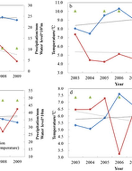
This study utilizes ICESat Release 33 GLA14 data to analyse water level variation of Xinjiang’s lakes and reservoirs from 2003 to 2009. By using Landsat images, lakes and reservoirs with area larger than 1 km2 are numerically delineated with a software tool. Based on ICESat observations, we analyse the characteristics of water level variation in different geographic environments, as well as investigate the reasons for the variation. Results indicate that climatic warming contributes to rising water levels in lakes in mountainous areas, especially for lakes that are recharged by snow and glacial melting. For lakes in oases, the water levels are affected jointly by human activity and climate change, while the water levels of reservoirs are mainly affected by human activity. Comparing the annual average rates of water levels, those of lakes are higher than those of reservoirs in oasis areas. The main reasons for the decreasing water levels in desert regions are the reduction of recharged runoff and high evaporation. By analysing the variation of water levels and water volume in different geologic environments, it is found that water level and volume increased in mountainous regions, and decreased in oasis regions and desert regions. Finding also demonstrate that decreasing volume is greater than increasing volume, which results in decreasing total volume of Xinjiang lakes and reservoirs.
Disciplines
Publication Date
2017
DOI
10.1371/journal.pone.0183800
Citation Information
Ye, Z., Liu, H., Chen, Y., Shu, S., Wu, Q., & Wang, S. (2017). Analysis of water level variation of lakes and reservoirs in Xinjiang, China using ICESat laser altimetry data (2003-2009). PLoS ONE. 12(9): e0183800. DOI: 10.1371/journal.pone.0183800