
Unpublished Paper
Mapping the interface between the intermediate sulphur water regime and deep brine in the Paleozoic bedrock of southwestern Ontario
(2018)
Abstract
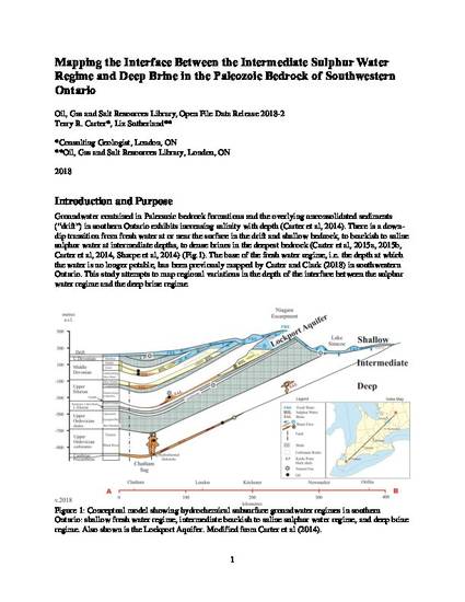
Groundwater contained in Paleozoic bedrock formations and the overlying unconsolidated sediments (“drift”) in southern Ontario exhibits increasing salinity with depth (Carter et al, 2014). There is a downdip transition from fresh water at or near the surface in the drift and shallow bedrock, to brackish to saline sulphur water at intermediate depths, to dense brines in the deepest bedrock (Carter et al, 2015a, 2015b, Carter et al, 2014, Sharpe et al, 2014) (Fig.1). The base of the fresh water regime, i.e. the depth at which the water is no longer potable, has been previously mapped by Carter and Clark (2018) in southwestern Ontario. This study attempts to map regional variations in the depth of the interface between the sulphur water regime and the deep brine regime.
Keywords
- Groundwater,
- Geology,
- Paleozoic,
- Southwestern Ontario
Disciplines
Publication Date
2018
Comments
Parts of this publication may be quoted and individual .jpg maps may be reproduced in reports if credit is given.
Citation Information
Carter, T.R., and Sutherland, L., 2018. Mapping the interface between the intermediate sulphur water regime and deep brine in the Paleozoic bedrock of southwestern Ontario; Oil, Gas and Salt Resources Library, Open File Data Release 2018-2.
Creative Commons License

This work is licensed under a Creative Commons CC_BY International License.