
Dr. Donna Calhoun
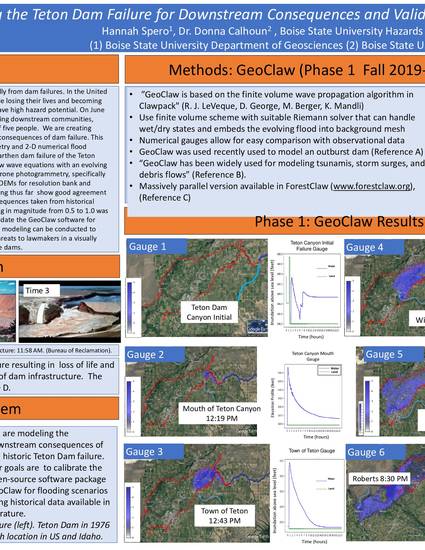
Worldwide there are threats from geohazards, and specifically from dam failures. In the United States, a dam failure could result in a million and a half people losing their lives. Over 20% of the dams within the United States have high hazard potential. On June 5th, 1976 the Teton Dam in eastern Idaho failed causing 2.9 billion dollars of damage and costing the lives of eleven people. We are creating numerical models to better understand the downstream consequences of dam failure. This work combines drone photogrammetry and 2-D numerical simulations to characterize the Teton Dam failure. The field methods are drone photogrammetry, specifically Structure for Motion (SfM) which improves the resolution of bank and floodplain topography. The preliminary results of the modeling thus far show agreement between the simulations gauge points and downstream consequences taken from historical literature. These findings validate the GeoClaw software for flooding scenarios. Future work focuses on implementing variable Manning’s roughness coefficient and improving the modeling of the dam failure mode. Dam modeling can aid in creating flood maps for local communities, communicating threats to lawmakers in a visually impactful way, and improving the design of future dams.
Available at: http://works.bepress.com/jeffrey_johnson/62/