
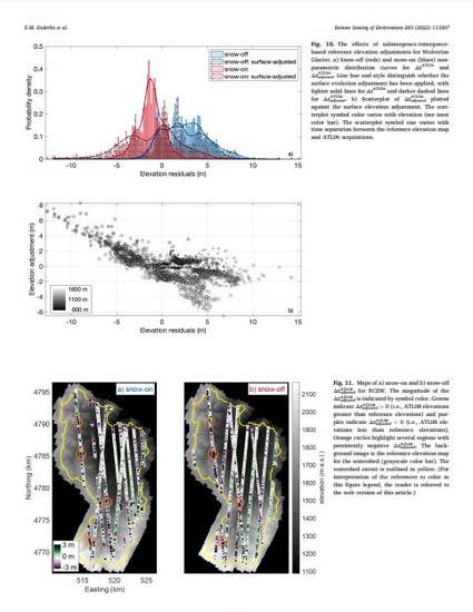
Seasonal snow melt dominates the hydrologic budget across a large portion of the globe. Snow accumulation and melt vary over a broad range of spatial scales, preventing accurate extrapolation of sparse in situ observations to watershed scales. The lidar onboard the Ice, Cloud, and land Elevation, Satellite (ICESat-2) was designed for precise mapping of ice sheets and sea ice, and here we assess the feasibility of snow depth-mapping using ICESat-2 data in more complex and rugged mountain landscapes. We explore the utility of ATL08 Land and Vegetation Height and ATL06 Land Ice Height differencing from reference elevation datasets in two end member study sites. We analyze ∼3 years of data for Reynolds Creek Experimental Watershed in Idaho's Owyhee Mountains and Wolverine Glacier in southcentral Alaska's Kenai Mountains. Our analysis reveals decimeter-scale uncertainties in derived snow depth and glacier mass balance at the watershed scale. Both accuracy and precision decrease as slope increases: the magnitudes of the median and median of the absolute deviation of elevation errors (MAD) vary from ∼0.2 m for slopes < 5° to > 1 m for slopes > 20°. For glacierized regions, failure to account for intra- and inter-annual evolution of glacier surface elevations can strongly bias ATL06 elevations, resulting in under-estimation of the mass balance gradient with elevation. Based on these results, we conclude that ATL08 and ATL06 observations are best suited for characterization of watershed-scale snow depth and mass balance gradients over relatively shallow slopes with thick snowpacks. In these regions, ICESat-2 elevation residual-derived snow depth and mass balance transects can provide valuable watershed scale constraints on terrain parameter- and model-derived estimates of snow accumulation and melt.