
Article
The Títulos de Ebtún, Yucatan, Mexico: Mapping Maya Communal Identity in a Colonial Spanish Notarial Context
Imago Mundi: The International Journal for the History of Cartography
(2015)
Abstract
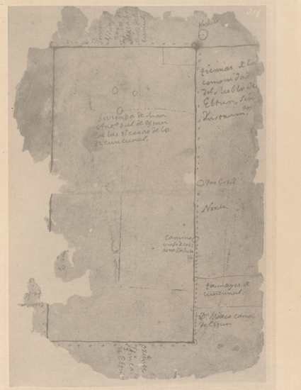
The main focus in this article is on four maps from colonial Yucatan, Mexico (c.1542‒1821). The maps illustrate a two-volume set of Maya notarial documents called the Títulos de Ebtún and concern disputed communal rights to Tontzimin, one of the sparse water sources (cenotes) of this arid limestone region, and its surrounding arable land. Mention is also made of two maps of the province of Mani that were included in treaties agreed with the Spanish authorities as a final record of Maya claims to traditional agricultural rights. Although all these maps were produced by Spanish officials, they relate to broader colonial mapping traditions in Yucatan and embody a clear Maya influence. At the same time, they reveal the effect of Maya mapping practices on Spanish notarial and mapping traditions at the close of the colonial period.
Keywords
- Yucatan,
- Ebtun,
- Cuncunul,
- Tontzimin,
- Maya,
- notarial papers,
- treaties,
- indigenous mapping,
- cenotes,
- sinkholes,
- land tenure,
- land disputes
Disciplines
Publication Date
2015
DOI
http://dx.doi.org/10.1080/03085694.2015.1027550
Citation Information
C. Cody Barteet. "The Títulos de Ebtún, Yucatan, Mexico: Mapping Maya Communal Identity in a Colonial Spanish Notarial Context" Imago Mundi: The International Journal for the History of Cartography Vol. 67 Iss. 2 (2015) p. 179 - 199 Available at: http://works.bepress.com/charles-barteet/4/