
- Cedar Lake,
- lake depth,
- lake bottom configuration,
- rate of infilling,
- lake volume,
- bottom-contour map,
- Surfer,
- drainage area
Cedar Lake on the campus of Cedarville University (CU) has a history that probably does not match what the original developers had envisioned. At present, the lake is the visual focal point of the campus and people often ask about its physical characteristics. The questioned characteristics include, but are not limited to, water depth, bottom configuration, water volume, drainage area that feeds it, rate of infilling, perimeter length, and lake surface area. This study considers the issues of potential changes in water depth, bottom configuration, and lake volume over an extended period of time, and further considers what to use as baseline data to start a long-term assessment. Changes to water depth, bottom configuration, and water volume in any lake are most often attributed to sediment infilling unless observed purposeful alteration by man is known to have occurred. A comparison of changes in total water volume of Cedar Lake will probably be the most valuable means by which the rate of infilling can be assessed.
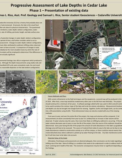
In the fall of 2012 the CU Environmental Geology class did an assignment which produced a bottom-contour map of Cedar Lake. Although the depth and position measurement techniques were somewhat crude, the end result was a map that seemed to be a very reasonable depiction on the lake bottom configuration. With certain refinements to the field techniques and the equipment, a second map will be produced in the fall of 2014. After that, a new map would be created every other year in the fall from new field data. The project should continue for a minimum of ten years. A software package called Surfer was used in 2012 and will continue to be used to produce the contour maps of the lake and to do the volume calculations.
Ultimately, if techniques and assessments are deemed adequate, then conclusions can be made regarding the infilling rate of the lake. Rate-of-infilling is a condition that needs to be understood in order to address both the short- and long-term health of the lake. The economic consequences may be minor or significant depending on the findings.
Available at: http://works.bepress.com/thomas_rice/1/